


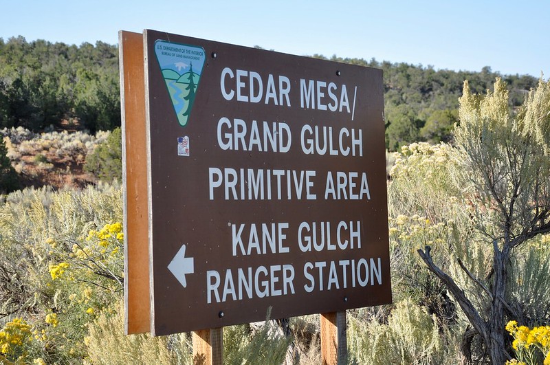
The Bears Ears region covers a lot of ground and for those who plan ahead, figuring out where the points of interest are located ahead of time does require doing some internet research. Planning ahead is really the only way to go, because internet service is extremely limited on location in the Bears Ears region. Fortunately, there are three local places to go where Bears Ears information can be gathered in person the old fashioned way. The Edge of the Cedars State Park Museum in Blanding offers volumes of information about the history of this region. The Bears Ears Education Center in Bluff offers everything that you will need for making a memorable Bears Ears venture happen. Detailed maps, pictorials and plenty of first hand knowledge can be found at the Bears Ears Education Center, which actually is a privately funded welcome center. The third local option for finding detailed Bears Ears information is the Kane Gulch Ranger Station, which is located on Utah State Road 261 near Highway 95. The BLM Kane Gulch Ranger Station is actually located on Cedar Mesa in the heart of Bears Ears, so this is the best place to find current information about the local dirt roads and hiking trail conditions. Protective site closures and limitations are also posted in this ranger station, which also are of help when planning the day's events. The rangers are well informed and they are used to answering plenty of questions from visitors seeking points of interest. Hiking trail maps can also be found here, which is a real plus! Visitors will be pleased to know that the Kane Gulch Ranger Station also has a campground with facilities and running water, which is a rarity in these parts. The central location on Cedar Mesa between the Moki Dugway and the Bears Ears Twin Buttes is ideal, because several hiking trails can be found nearby. One of the best Bears Ears hiking trails actually starts at the ranger station and it goes about 4 miles through the wilderness to an ancient pueblo that actually has turkey pens. This day trek hike certainly is an educational experience that is worth pursuing, so be sure to grab a map while there!
0 Comments
Your comment will be posted after it is approved.
Leave a Reply. |
Leave no trace!
New!
Destination West YouTube channel! https://www.youtube.com/@DestinationWestOrg *This website will be going through renovations soon. Separate destination articles will be combined after the videos replace the outdated photo gallery system. As many readers know, most of the writing was done on the fly while camping, so many articles read like a rough draft. The articles will be cleaned up and edited. Many of the old photos were straight out of the camera due camping limitations and the quality will be bumped up. Another goal is to make navigating the index pages easier and combining separate articles will help. This website will continue into the future and your patience is greatly appreciated!
JD Lane Archives
April 2024
|
